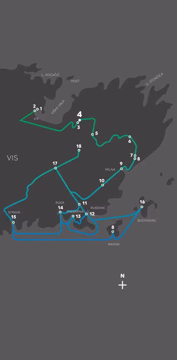
Geostaza Vis Rukavac
1. VIS-RUKAVAC GEOTRAIL
Dear visitors-geoexplorers,
The Geotrail in front of you will introduce you to the geological processes that gave birth to the island of Vis and will also acquaint you with the island’s rich history. By following this Geotrail, you will learn about the geology of the island, see some spectacular fossils, and discover that the climate of the island throughout its geological history was quite different than today. You will behold the remains of dunes that have been transformed into sandy fields suitable for viticulture and olive growing and view many beautiful and spectacular coves ranked among the world’s most enchanting
Our story starts in Mesozoic. The area of the island of Vis was then located in the tropics in the middle of the ancient Tethys Ocean, on a small mobile continent between Africa and Europe, called Adriatic microplate or Adria. Present-day Dalmatia was flattened area called Adriatic Carbonate Platform, covered with a shallow warm sea and low sandy islands with tropical plants, like today Bahamas.
Southern coast of the island of Vis is built mainly of limestone originated from a pure life, as evidenced by spectacular clusters of rudist shells. Rudists are the most numerous large shallow-water fossils in deposits of the Adriatic Carbonate Platform of the Cretaceous age. Rudists are extinct bivalves of bizarre shapes, which disappeared from the Earth along with the dinosaurs because of the impact of an asteroid 66 million years ago.
At the end of the last Ice Age, 25,000 years ago, sea level was about 120 meters lower than today, and the dissolution of limestone by rainwater (karstification) reaching deeper into the surface layer of the Earth's crust. Due to differences in the microstructure and chemical composition, dolomites are less permeable than karstified limestone. Thus, the dolomites "hold water", which is very important for the water supply of the island. Due to the lower sea-level, the islands were hills in the middle of the Adriatic steppe. Strong southerly winds blew up the sand, while the migrating sand dunes created sandy plains on the hills. Raising sea after the Ice Age flooded the canyons and karst caves that were partly collapsed because of the specific geological structure and the action of the sea (abrasion), yielding the most beautiful coastal geomorphological features of the Adriatic.
1.1 Overview of the evolution of life on Earth trough geological ages
1.2 Paleogeographic sketch-map of the Adriatic Carbonate Platform (ACP) and the present-day island of Vis position (red arrow) 66 million years ago
1.3 Central Adriatic paleomap during the Last Ice Age


2. GREEK AND ROMAN ISSA
Today’s town of Vis began as the city-state of Issa, founded by Greek colonists from Syracuse in Sicily at the beginning of the fourth century B.C. A surviving section of the ancient street provides the starting point for the Geotrail, which ends on the opposite, south-eastern side of the island at Srebrna Bay’s ancient quarry, a source of stone for the construction of Issa.
Issa was the centre of urban civilization in the eastern Adriatic. In addition to being a center for literature and the arts, Issa was known for its wine-growing culture, its detailed land registry records, and as the first ancient city-state to use money as a means of payment. Its affluence derived from the trade of its wine and pottery, and the high level of civilization and culture attained is attested by numerous surviving archaeological sites—Greek cemeteries (necropoli), residential buildings and streets, a public theatre and Roman baths (thermae)—and objects, the most renowned of which is a bronze head depicting Artemis. Many ancient inscriptions survive in the cemeteries, the most important being a poem inscribed on the tombstone (stela) of the hero Calius, who was killed defending Issa from the Illyrians in a naval battle. It is the oldest such inscription discovered in Croatia to date.
Among the ruins of the Roman baths is a remarkable floor mosaic of dolphins and geometrical motifs from the second century A.D., in the northern part of the complex. The baths were valued not only for their medicinal purposes but as the hub of Issa’s social and cultural life. The Romans also built a theatre on the Prirovo Peninsula; in the sixteenth century a Franciscan monastery was built over its remains. The monastery’s walls trace the semi-circular shape of the theatre’s auditorium, which was small to medium in size. In Julius Caesar’s commentary on the Alexandrian War is written: “On the island of Issa there is a town of the same name, the most distinguished town in the region.”


3. PETRIFIED ALGAL MEADOWS FROM THE AGE OF DINOSAURS
This cross-section of a dolomitic boulder, visible along the winding road leading from Vis to this viewing point, provides a window into its geological story. Dolomite is darker than limestone and is created by a gradual change in the chemical composition and microstructures of limestone originally deposited late in the Mesozoic Era, the Age of the Dinosaurs. Today’s island of Vis was then located in a tropical belt in the middle of the ancient Tethys Ocean, on a small mobile continent between Africa and Europe known as the Adriatic/Apulian Plate. Present-day Dalmatia was then a flatland, the Adriatic Carbonate Platform, partially inundated by a warm, shallow sea and dotted with low, sandy islets covered in tropical vegetation, like the Bahamas today. These spacious flatlands were covered in slimy algal meadows, which flooded with the ebb and flow of the tides; during each tidal exchange the fine carbonate mud would stick to the algal meadows in millimetre-thick deposits, creating the rocks we know as laminated carbonate or stromatolite. There are many fossil shells embedded in these sediments, which also contain traces of plant roots and minerals formed as the ancient seabed dried. After decomposition of lumpy aggregates of algae in the fresh carbonate rock transparent calcite has been precipitated forming so-called fenestrae.


4. VIS BAY
The view from this vantage point encompasses the entirety of Vis Bay, a deeply recessed natural harbour which has sheltered mariners since ancient times. It also provided a natural, easily defended stronghold for the many armies which have passed through Vis in its history. The ancient Greek town of Issa was located on a southward-facing slope in the western part of the town of Vis, behind Prirovo Peninsula. Two separate settlements developed in Vis Bay in the sixteenth and seventeenth centuries: the Luka settlement on the west side of the bay and the Kut settlement just below this viewing point on the eastern side. These two settlements eventually merged into one, the town of Vis. This is also the reason for the town’s elongated shape along the edge of the entire bay.
An integral part of the identity of Vis and its bay are numerous sites which commemorate great historical events. From the early nineteenth century, when Vis was under British rule and christened the “Gibraltar of the Adriatic” for its strategic importance, a large number of place-names memorializing historical events or figures (toponyms) have been preserved. Host Island at the entrance to the port of Vis houses the remains of battery pieces used in an 1811 battle between the British and the French, and bears the name of the British captain William Hoste, who was wounded in the battle and transferred from his warship to this islet. Other place-names include Porto Inglese Bay (today known as Stonca); Fort George, erected in 1812 and named after George III of the United Kingdom; the fort of Terjun or Bentinck, named after William Cavendish-Bentinck, commander of the British forces in Sicily; Robertson Fort, named after the commander of Vis, George Duncan Robertson; and Wellington Fort on St. George Hill, named after the Duke of Wellington, who defeated Napoleon in the Waterloo Campaign of 1815.

5. ZLOPOLJE: SAND DUNES FROM THE LAST ICE AGE
Zlopolje is the first in the line of fertile fields located on the continental part of Vis along the Geotrail route. Next along the new road connecting Zlopolje and Rukavac are Borovo Polje and Tihobraće Polje (polje is Croatian for “fields”), followed by a view across the highly indented south-eastern coast of Vis with its multitude of islets. West of these are the Ljubišće Fields—Velo (large) and Malo (small) Jubišće in local dialect—as well as Vošćice Field and the largest fields on Vis, Velo Polje (Velo Poje, in dialect).
At the end of the Last Ice Age, some 25,000 years ago, the sea-level was approximately 120 metres lower than today. The present-day islands were merely hills in the middle of the Adriatic steppe. Strong southern winds carried sand, and formed migrating sand dunes on these hills. Fields were created by the closure of former valleys by the migrating dunes, resulting in slanted layers of sand. Due to the flow of rainwater rich in calcium carbonate through the sand, so-called loess dolls (mineral masses) were gradually formed in the weakly-bound slanted sandstone sediment. Due to their high degree of moisture retention, the sand fields are very fertile and yield the highest quality grapes of the native grape variety, Plavac Mali.
Sand from Zlopolje was once extracted in significant amounts for use in construction, and over time a large gaping pit was created near Karvovac, the best sight for observing the composition of the soil in this field.
In the early eighteenth century an ancient inscription was discovered near Zlopolje that commemorated the establishment of a vineyard there, an occasion both festive and solemn for a Roman landowner. The text was recorded by the accomplished polymath Antun Matijašević Karamaneo (1658-1721): “To Jupiter, the most high and holy, this [marker] is consecrated. Gaius Valius Festus planted a vineyard in this location, which he will, for now and forever, call Festus. Fulfilling his vow, he made an altar and consecrated it by sacrificing a bull.” The inscription was later taken to a house in the town of Hvar, where it was destroyed in the nineteenth century (Zaninović, 1997).


6. STONČICA, A BAY AND LIGHTHOUSE
Bays on the eastern and south-eastern coast of Vis have Aeolian sand beaches, which date back to the glacial period. This sand was carried by winds from the flatlands which surrounded the hill of Vis before the sea-level rose 120 metres. One such bay is Stončica, which is very shallow due to these sand deposits. This bay was included in the Natura 2000 ecological network. The water in this bay can be several degrees warmer than that in the other bays of Vis due to its shallowness; it does not surpass average human height for 30 metres from the shore.
On Cape Stončica (3 km by air from this information board), there is an octagonal stone lighthouse built in 1865. It is 28 metres high: its main light can reach up to 30 miles, and its spare light, up to 12.
During a surprise attack by a French warship on Vis (then part of the Austro-Hungarian Empire) in October 1914, the lighthouse was heavily damaged by bombing and both lighthouse keepers killed. It was restored after the end of the First World War.


7. THE SCENIC VIEWPOINT ABOVE THE VILLAGE OF ŽENKA
Stretching before us is a group of islands on the south-eastern coast of Vis, with a number of cliffs and islets. These are, from left to right: Greben, Veli Paržanj, Mali Paržanj, Veli Budihovac, Mali Budihovac, and Ravnik. These islands are covered in Mediterranean shrubbery and many other medicinal plants, rosemary being the most renowned among them. Rosemary oil, named quinta esencia by the founder of modern medicine, the Swiss alchemist Paracelsus (sixteenth century), is extracted from its leaves. Paracelsus believed this oil had the miraculous ability to cure all illnesses. There is plenty of rosemary on the islands of Ravnik and Budikovac.
Among all these islands, the most attractive is Budikovac, with its spacious beach and shallow lagoon bay; its neighbor Ravnik is renowned for the Green Cave. Budikovac is also the only island in this group suitable for agriculture because of its fertile sand field, where today there is a vineyard planted with the native grape variety Plavac Mali. This variety has a high sugar content and produces top-quality red wine. The most frequently used port for accessing both of these islands is Rukavac, some 4 km from this viewpoint.
Above the group of islands along the south-eastern coast of Vis are (from east to west) the settlements Ženka, Milna, Podstražje, Bargujac, and Rukavac (Upper and Lower).
Rukavac, today the largest settlement on this part of the island, was once a small fishing village, with a cannery built in the late nineteenth century. Of greater importance in the past was the nearby village of Postražje, located farther from the sea, which contained the public facilities for this part of the island, including the school (closed in 1964).
Today, the south-eastern coast of Vis has become a tourist mecca. In the last fifty years hundreds of structures have been built here to accommodate the tourist traffic, which has completely transformed the character of the settlements.


8. RAVNIK AND THE GREEN CAVE
The most important natural feature of the islet of Ravnik is the Green Cave, a partially submerged cave with two large entrances. It was formed when horizontal rock layers collapsed under the pressure of strong waves and earthquakes. In the centre of its high dome is an opening through which sunrays enter and illuminate the bottom of the sea below, creating a wondrous green reflection and the illusion that the sun is shining from underneath the sea. The Green Cave is also of geological interest: the rock contains fossil remains of the extinct marine bivalves known as rudists, a major component of the reefs of the ancient Tethys Ocean during the Cretaceous Period. The rudists perished in the Cretaceous-Paleogene mass extinction event which brought the entire Mesozoic Era--- the Age of Reptiles and Conifers--- to a close.
In the past, the Green Cave provided shelter to fishermen who sought refuge from stormy weather; or simply a space to clean their nets, sort their fish, or rest a while from their labors.
In 1875, the cave on the island of Ravnik was visited by Austro-Hungarian Emperor Joseph I on his boat while travelling from Komiža to Vis. Numerous other travelogue writers described the cave as they visited the Vis archipelago at the turn of the nineteenth to the twentieth century. American travel author Maude H. Holbach, in Dalmatia: The Land Where East Meets West (New York, 1908), wrote that the Green Cave on Ravnik “evokes the Roman pantheon with the shape of its dome and the central opening in the middle of it, through which sunrays flow towards the mirror-still surface of the sea below.”
British explorer and travel writer Richard F. Burton quoted Coglievin who, in his book, described the Green Cave as a “tunnel in the limestone cliff, with two arched entrances creating a natural pillar, and with an unusually geometrical interior (…) pierced through by a magical ray of light descending from the opening in the dome which looks perfectly shaped as if by someone's hand. He said that in the old poetic days of ancient Greeks this cave would have been [a] harbour where the Nereids gathered.”
In spite of its beauty and the many descriptions of this cave written down by travellers from abroad, the Green Cave on the islet of Ravnik has, for a long time, stood in the shadow of the more famous Blue Cave on the island of Biševo.

9. MILNA
Milna is a recent settlement created by the surge in tourism within the last fifty years. Before the Second World War, the only house located here was owned by the wealthy Pušić family from Vis. In the mid-1930s, the Villa Ana was built by Ana Marinović, a woman from Vis. During World War II, Marinović permanently left Vis and went abroad, leaving her villa as an infirmary for wounded soldiers and war invalids.
The name for the settlement and bay, Milna, is derived from the word milo, “shallow” in the Vis dialect (from milura, Croatian pličina, or “shallow water”). Milna was named after its shallow sandy bay. In addition to Milna on the island of Vis, there are places with this name on the neighbouring islands of Hvar and Brač.
Some one kilometre south of Milna Bay is the beautiful sandy cove of Zaglav, which can be reached by foot along a small path or by boat.


10. ALLIES OF WORLD WAR II CEMETERY
In a field between Milna Bay and Podstražje village there is a pyramid surmounted by a cross, a monument to the cemetery of Allied soldiers which existed here between 1944 and 1948. Each of the four sides of the pyramid is inscribed with one of the "Four Freedoms" proclaimed by U.S. President Franklin D. Roosevelt in the State of the Union speech of January 6th, 1941: Freedom of Speech, Freedom of Worship, Freedom from Want, and Freedom from Fear.
Interred in this cemetery were American and British soldiers killed during operations spear-headed from Vis, where the Allies joined the Yugoslav Partisans to defend this last unconquered bastion in the Dalmatian archipelago. The defense of Vis relied on Allied forces in southern Italy, and large numbers of Allied soldiers were stationed on the island in 1944 alongside Tito and his fighters. Approximately two kilometres west of this site, in the vicinity of Velo Polje, was an Allied airstrip.
The Anglican Bishop of Lichfield, Dr. Edward Woods, arrived on Vis in June 1944 to consecrate this cemetery in which 22 U.S. and 40 British soldiers were buried. After the Second World War, their remains were exhumed and transported to a military cemetery in Belgrade.
Dennis Johnston, a BBC war reporter who arrived in March 1944 to document Hitler's anticipated invasion of Vis, wrote in his diary: “[The Partisans] did not wait for Allied assistance, but started the battle on their own. For some time they were completely alone, while engaging more enemy divisions than the Allied forces in Italy. At times it seemed that they had taken on an impossible and hopeless task. But they persisted, and endured, and now they have friends on their side. And aid from the Allied forces which grows with each passing day.”


11. TECTONIC RECORDS FROM THE LAYERS OF ROCK
The southern coast of the island of Vis was formed by layers of limestone deposited on the Adriatic Carbonate Platform during the Cretaceous Period. At that time this area was covered by a warm, shallow sea and low sand islets covered with tropical vegetation, much like the Bahamas today.
In these rocks we find a tectonic record of the stretching of the Earth’s crust, which created space for the deposition of mud and sand on the former shallow sea-bottom. Numerous fast-growing organisms inhabited this warm tropical sea and produced carbonate shells; these fell to the sea-bottom as the organisms died, producing layers of carbonate mud and sand that quickly filled the sedimentary space. The mud and sand slowly hardened into rock, creating layers of limestone around the fossils of extinct organisms, such as rudist shells (ancient reef building bivalves). These layers were deformed by the collision of the Adriatic and European plates in the Cenozoic Era, when the geological structure of today’s island of Vis was established.


12. RUKAVAC FISHING VILLAGE AND FISH FACTORY
Rukavac is a fishing village and a port (frequently referred to as Porto Manego on historical maps) and also location of the ruins of the former Mardešić Cannery built in the late nineteenth century. This cannery was a branch of Komiža’s Mardešić Cannery, centre of the fishing industry on the Adriatic. The Mardešić Cannery in Komiža, the oldest in the Mediterranean, was founded in 1870. In this harbour, the cannery produced barrels for salting fish; fishermen from this area mainly worked the rich fishing grounds near the southern coast of Vis and the island of Sušac, where they found large quantities of small pelagic fish. In old photographs of Rukavac, one can see typical gajeta fishing boats loaded with barrels of salted sardines ready to sail back to their home ports.


13. SREBRNA BAY
This is one of the most beautiful and popular beaches on the island of Vis, covered with large white limestone pebbles softened by the sea and scattered across carbonate rocks. The beach is surrounded by south-facing stone slabs perfect for sunbathing. Intact in these rocks are large deposits of rudist shells preserved at the exact location where they grew some 90 million years ago.
A. Roki stated that the correct name for this bay is Lubandjera, and that Srebrna (in Vis dialect, Srebarna, or “silver”) is actually the name of a smaller, neighbouring bay west of this beach on the way to Ruda Bay. Today, the name Srebrna is used exclusively and the older name has become obsolete. There are two theories regarding the origins of the present-day name. According to the first, the beach was named Srebrna because stone slabs from the Srebrna quarry had a nice silver colour after being washed down (Katić, 2009). According to the other, this was a fishing post where large quantities of fish were caught; the large number of fish scales on the bottom of the sea gave off a silver colour (Roki, 1997).
In Srebrna Bay, one can see traces of the quarrying which took place 2,400 years ago to supply stone blocks for construction of the ancient Greek colony of Issa. The Greek colonists arrived from Syracuse in Sicily in the early fourth century B.C. and chose this site for the quarry, since ships could be moored in the bay for a seven-mile transport to Issa. Since then, the sea-level has risen by two metres and the oldest part of the quarry is now submerged. The quarry extends in a north-south direction along the present-day beach. It may have also supplied other Greek colonies such as Faros (now the town of Stari Grad on the island of Hvar) and is one of the oldest quarries in present-day Croatia (Katić, 2009).
Stone from Srebrna Bay was used for the construction of houses in nearby villages up until the twentieth century; this more recent quarrying has left the most visible signs.


14. RUDA BAY
One of the many bays on the southern coast of the island of Vis, Ruda Bay is located between the famous bays of Srebrna (to the east) and Vela Travna (to the west), and separated from the latter by the Termule Peninsula. There is an old fisherman’s saying about Termule Peninsula (toponym: Puntin ol Gospe, the “Small Cape of our Lady”): molat vesla i zlamenovot se, “let go of the oars and let yourself cross.” The cave Virina spila is also found here, which, as the legend goes, was once inhabited by the Mediterranean monk seal (J. Repanić, 2009).
Each of the numerous bays on the southern coast of Vis belonged to one of the villages on the inland. Ruda was used by the villagers from Marinje Zemlje and Plisko Polje some two kilometres to the northwest, who maintained fishing huts on the bay. Ruda is connected to these villages by an old trail that dates to ancient times. It is assumed this trail was once used to transport stone from the quarry in Srebrna to build Roman villas further inland, and more recently to build country houses for the nobles of Komiža and Vis.
The southern coast of the island of Vis is primarily composed of seashell limestone, and the rocks of Ruda Bay have the largest concentration of marine fossils. Most spectacular are the fossilized clusters of rudist shells, the largest of the shallow-water fossils found in the rocks of the Adriatic Carbonate Platform from the Cretaceous Period. Rudists were ancient marine bivalves of unusual shapes, frequently resembling ice cream cones, which perished along with the dinosaurs after an asteroid hit Earth some 66 million years ago.
In addition to rudists, we also come across numerous other microfossils in these rocks; for example, gigantic petrified sea sponges and other inhabitants of these shallow tropical seas who contributed to the production of carbonate and the deposition of mud and sand from which limestone layers were formed. These layers formed the Adriatic Carbonate Platform during the Mesozoic Era and were subsequent deformed by tectonic events in the Cenozoic Period, creating the geological structures of Vis as we encounter it today.


15. STINIVA
The partially submerged canyon of Stiniva Bay was formed during the Last Ice Age, when the sea-level was 120 metres lower than today. As a result of intermittent torrents in the stream that carved the canyon, a limestone cave formed underground and then collapsed, perhaps a few thousand years ago. This is the reason for the cave-like formations found on the eastern cliffs of the bay today. After the global rise in sea-level during the Last Ice Age, waves broke through the narrowest part of the cave wall on its seaward side. In the intervening years the rising sea has flooded the lower part of the canyon and the collapsed cave, slowly eroding the limestone fragments of the its former ceiling into the smooth pebbles of the present-day beach. The canyon rocks’s themselves are limestone layers from the Age of the Dinosaurs (Mesozoic). In these layers are found the brown shells of the rudists (ancient marine bivalves) that lived in the mud on the sea-bottom, and the laminated limestones formed by deposition of algal debris on the tidal plain.
Before the onset of tourism, this bay was used as a fishing harbour and refuge. On maps from the first half of the nineteenth century the bay is also called Besdia (Bezdija). Here the fishermen kept their boats, salted their sardine catches in wooden barrels, dried and mended their nets, kept their fishing tools in stone huts, and swapped stories about fishing, the weather, and the vicissitudes of life. These were villagers from Žužec, located on the hillside above Stiniva Bay, to which it is connected by a steep goat path.
The picturesque scenery of these fishing villages also attracted famous painters, the most renowned of whom was the Zagreb painter Đuro Tiljak (1895-1965). Tiljak visited the island frequently in the 1930s and depicted the lives of fishermen in Komiža and the enchanting fishing enclave of Stiniva Bay. In 1965 he published a map entitled Graphics of the Island of Vis, and in 1966 the “Memorial Collection of Đuro Tiljak” was established in Komiža.
Stiniva Bay was declared a “National Significant Landscape” in 1967, and any activity that might endanger its beauty or ecological health is forbidden. Until recently Stiniva was not well-known outside Vis, but has increasingly been found on lists of “the best beaches” in Croatia and Europe; visitation has consequently exploded.


16. THE ISLAND OF BUDIKOVAC: PALEOSOILS, SAND, PEBBLES, AND BLUE LAGOON ON A FLOODED ROCKY HILL
Budikovac is a low island composed primarily of grey dolomitic rock, one of the southeastern satellite islands of Vis. Geological interest, the crystal-blue clarity of the water, two beaches, a shallow lagoon, and the deeply sculpted coastline, all make Budikovac one of the most attractive islands in the Adriatic archipelago.
25,000 years ago at the end of the Last Ice Age the sea-level was 120 metres lower than today. Strong southern winds blew eroded sands uphill from this ancient shoreline to cover most of the present-day island. This sand now covers the carbonate platform (bedrock) and paleosol (ancient soil) in the low-lying areas, providing an ideal medium for growing the native Plavac Mali (or “Small Blue”) red wine variety. The beaches of Budikovac are a mixture of this Aeolian (wind-eroded) Ice Age sand with tiny pebbles, which reveal themselves under a magnifying glass to be the finely crushed shells of sea snails and other marine fauna.
The vineyard on Budikovac dates back to the time of ancient Greek Issa. Wine produced on Budikovac was known for its superlative quality across the Mediterranean, and mentioned by the famed geographer Agatharchides, director of the Library of Alexandria in the second century B.C. The exquisite taste of red wines from Budikovac later beguiled Marshal Tito, whose banquets included lobsters from Komiža and Plavac Mali from Budikovac.
In his travelogue A Visit to Lissa and Pelagosa (1880) the Victorian adventurer Sir Richard Burton reports that Maximilian of the House of Habsburg-Lorraine (1832-1867)—briefly Maximilian I, Emperor of Mexico—entertained the idea of buying Budikovac to build a summer residence there, before settling on the more accessible island of Lokrum, near Dubrovnik, instead.
Prior to the nationalization process which followed World War Two, the island of Budikovac was the private possession of the Pušić family from Vis.


17. LOKVA: LIMESTONE KARSTIFICATION AND DOLOMITES - WATER-HOLDERS IN THE KARST
Eastern part of the island is characterized by a relatively simple large antiform geological structure that resulted from long-term tectonic processes. The structure is in the central part built mainly of dolomite (CaMg (CO₃)₂). These darker rocks resulting from gradual change of the chemical composition and microstructure of original limestone (CaCO₃), precipitated at the time of the dinosaurs - Mesozoic. Due to differences in the microstructure and chemical composition, dolomites are less permeable than porous karstified limestone. Therefore dolomite "hold water" which is very important for the water supply of the island, and after larger rain the fields that have basement of a dolomite rock are flooded.
During the last Ice Age, 25,000 years ago, sea level was about 120 meters lower than today, and the dissolution of limestone by the rainwater (karstification) reaching deeper into the surface layer of the Earth's crust.
Karst underground of Vis island is filled with sea water in depth, and in the upper part, due to differences in the density, there is a lens of fresh and brackish (saline) water which is renewing by rainwater. The lens of fresh water is pumped and used for water supply of the island.


18. DRY WALLS AND VINEYARDS
The wine-growing island Vis has been draped in a matrix of dry stone walls since ancient times. This rural architecture provides the motif for the island's visual identity, zig-zagging wilfully hither and thither in whatever capricious pattern is necessitated by the contours of the rocky terrain. This “peasant manuscript”—written in stone, and created over centuries by the epic struggle to reclaim every inch of fertile land from the rocks and the heather—records the story of survival, the story of hardships endured by generations of wine growers to transform a stark and unforgiving landscape into a fertile tapestry of vineyards terraced right up to the summits of the hills.
Up until half a century ago, all the hills you can see surrounding Vis Bay were covered in vineyards. Today they are mostly covered with pine trees, and unsuspecting visitors who spot stone formations are sometimes led to believe that they resulted from natural processes, not painstaking human toil. Geological records illustrate the dynamics of the Earth’s formation over millions of years; these signposts formed by human hands tell the story of thousands of years of mankind’s struggle.
Unlike Komiža, where fishing was the dominant activity, wine-growing was the basis of economy of the town of Vis up until the Second World War. “The Golden Age” of wine-making on Vis was the second half of the nineteenth century and the early twentieth century. According to the 1910 census, the island of Vis—with as much as one-quarter of its land covered in vineyards—had close to 10,000 inhabitants (in 2011, the island had circa 3,500 inhabitants), and the population of the town of Vis was approximately 4,300 (in 2011, it was about 1,700). Wine from Vis was renowned and exported all across the Austro-Hungarian Empire. In just one year, 1890, Vis produced and exported 100,000 hectolitres of wine. It was during this era of affluence that most of the public structures and private houses in Vis were built. Two events halted the development of wine-growing on Vis: first, the “Wine Clause” (1891-1905), which allowed Italian wines to be sold in the Austro-Hungarian Empire. After the clause was abolished, just before the First World War, the disease phylloxera devastated the vineyards on Vis. After the war they were replanted and restored, but wine production never fully recovered, due to the breakup of the Austro-Hungarian Empire and its large wine market.


Hrvatskih mučenika 17
21485 Komiža, Croatia
+385 91 271 30 23
geopark@geopark-vis.com
Photography: Ivo Pervan, Matko Petrić, Stjepan Mekinić
Design & development: P3R0
