Protected monuments of nature and significant landscapes
The Blue Cave
a geomorphological monument of nature
The Blue Cave (Modra špilja), located in Balun Bay on the island of Biševo, has been a protected geomorphological monument of nature since 1951 and is a key site of the UNESCO Global Geopark Vis Archipelago. In the cave's hinterland, traces of tectonic forces that fractured and displaced blocks of the Earth's crust are visible. At this location, the cave block scraped against the main mass of the island, creating a fault plane known as a paraclase. The cave was formed through selective erosion (abrasion) after the Ice Age. Since the rocks at the level of the submerged entrance were softer than the surrounding limestone, powerful waves hollowed them out more easily—a sculpting process that continues today.
The distinctive blue glow is created by sunlight penetrating through an underwater opening at a depth of 12 meters. The light reflects off the bright sandy bottom, illuminating the interior. This specific ecosystem is inhabited by 119 taxa of marine organisms, five of which are strictly protected.
Although it was previously known to local fishermen, the cave was revealed to the wider public in 1884 by the Austrian explorer Eugen von Ransonnet. At his suggestion, the current entrance at sea level was blasted through, making the site accessible to small boats.

The Monk Seal Cave
a geomorphological monument of nature
The Monk Seal Cave (Medvidina špilja) is located in Trešjavac Bay on the southern coast of the island of Biševo. Due to its unique morphology, it has been protected as a geomorphological monument of nature since 1967.
The cave was formed by the action of tectonic forces along a fault plane in Lower Cretaceous dolomites. Its monumental entrance, 27 meters high and 14 meters wide, leads into a 160-meter-long interior, making it the longest semi-submerged cave on the eastern coast of the Adriatic. The main atrium gradually narrows and ends at a small beach deep inside the rock.
It is named after the Mediterranean monk seal (Monachus monachus), which used the beach at the end of the cave to raise its pups. Today, the cave is an important habitat for numerous other species; schools of big-scale sand smelts (Atherina boyeri) inhabit the first atrium, while mysid shrimp (Hemimysis) live in the darker sections. The rocks are covered with colonies of sponges and bryozoans, along with strictly protected species such as the purple starfish (Ophidiaster ophidianus), the lurid cowrie snail (Luria lurida), and the golden coral shrimp (Stenopus spinosus).
In local tradition, the cave is known as "Poseidon's Gate." Today, entry is strictly restricted to protect the sensitive ecosystem and due to the risk of rockfalls. In order to preserve the habitat for the potential return of the Mediterranean monk seal, using lights, making noise, and going to the beach itself are prohibited inside the cave.

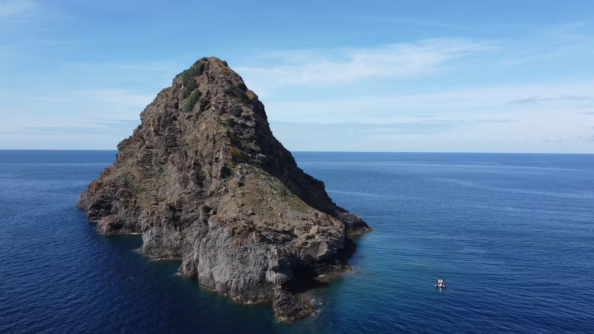
Jabuka islet
a geological monument of nature
The island of Jabuka is located in the open sea, thirty miles west of Komiža. It is 97 meters high with a circumference of about 700 meters, and due to its unique characteristics, it was declared a geological monument of nature back in 1958. It is composed of diabase, a deep-seated igneous rock that contains magnetite. Because of this, ship compasses malfunction near the island, making navigation difficult for sailors in poor visibility.
The island has no bays or shelter from the wind, the deep seabed makes anchoring difficult, and the rocks are too smooth to tie up a boat. Despite these dangers and the lack of a harbor, fishermen from Komiža regularly sailed to Jabuka in their falkuša boats during the winter months, drawn by the seabed rich in fish and crabs. Today, about twenty recorded toponyms bear witness to their presence on this desolate edge of the Adriatic.
Due to its complete isolation, Jabuka is also a habitat for unique endemic species. Its black rocks are home to the Jabuka black lizard (Podarcis melisellensis pomoensis) and two endemic plant species, Centaurea jabukensis and Centaurea chritmifolia.
The Green Cave on the islet of Ravnik
geomorphological monument of nature
The Green Cave (Zelena špilja) is located on the islet of Ravnik and has been protected as a geomorphological monument of nature since 1967. This spacious cave with two large entrances is one of the most attractive sites in the Vis Archipelago.
The cave was formed by the abrasive action of sea waves, which eroded and hollowed out the limestone layers over a long period. Its interior is characterized by high vaults and monumental openings that allow small boats to enter.
The unique feature of the Green Cave is a circular opening on its ceiling, through which sunlight penetrates like a powerful spotlight, illuminating the sea all the way to the bottom. The distinctive greenish color of the interior is a result of light refraction on the sea surface and the presence of algae covering the rocks and the seabed.
As a natural attraction, the cave drew explorers and travelers as early as the 19th century. Among its most notable visitors was the Austrian Emperor Franz Joseph I, bearing witness to the long tradition of admiration for this natural phenomenon.

Stiniva Bay
a significant landscape
Stiniva, a pebble bay on the island of Vis, has been protected as a significant landscape and monument of nature since 1967. It was formed by the collapse of a karst cave during the Ice Age, when the sea level was lower. Surrounded by high limestone cliffs, the bay creates shade and a dramatic impression. Stiniva is accessible by sea or via steep paths, which preserves its untouched beauty. This beach is frequently declared one of the most beautiful in Europe and the world, attracting visitors from all over.

Ravnik
a significant landscape
The islet of Ravnik (0,27 km²) is located off the eastern coast of the island of Vis, approximately 800 m removed from the village of Rukavac on the coast of Vis. It is protected as a significant landscape, and its greatest attraction is its Green Cave on its west coast, protected as a geomorphological monument of nature since 1967.

Brusnik
a geological monument of nature
Brusnik is removed 13 nautical miles from Komiža, in direction west, south – west. Alongside the Island of Jabuka, it is the only Adriatic island formed mainly from igneous rock. Brusnik rises 23 meters above the sea surface, it is around 200 meters long and 150 meters wide.
Unlike Komiža's vulcanites formed by the cooling of molten rock on the brims of na anciant volcano, Brusnik and Jabuka are made of subvolcanicdiabaseformed by crystallization of magma on its way from the deepmagmatic core to the surface. The Island of Brusnik is far more complex than Jabuka, which is entirely formed from the diabase. Brusnik is a „rising“ island. Paleo-beach pebble conglomerates can be found on the island's very top, which inidactes its more recent rice. There is an enedemic black lizard specie Podarcis melisellensis living on the island.
In the middle of the island there is a ravine with depression filled with a sea, as fishermen from Komiža used and made larger pools with seawater of pebbles for keeping caught lobster. On its great shore of black pebble conglomerates, you can see the remains of a fishing cottages built from large pebble. These miniature homes covered by the bushes from the nearby island of the St. Andria used to serve for the salting blue fish in barrels and to keep fishermen away from sun and wind. As part of the geological story, there is an inescapable fishermen story about fishermen who hunted lobsters for European metropolises during the winter, long before tourism came.
The Island of Brusnik was declared a protected area in 1951, int he category of geological monuments of naturedue to its magmatic origin and extraordinarly rare minerological and petrographicstructure, since our islands are usually built of limestone.


Hrvatskih mučenika 17
21485 Komiža, Croatia
+385 91 271 30 23
geopark@geopark-vis.com
Fotografije: Ivo Pervan, Matko Petrić, Stjepan Mekinić
Design & development: P3R0
